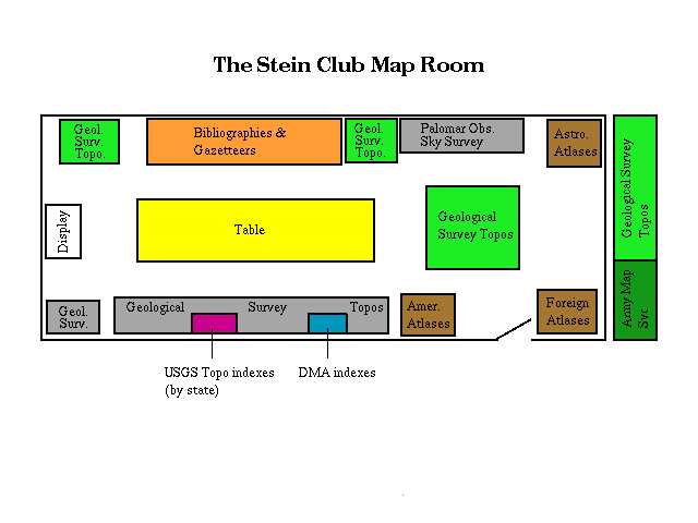
- American Atlases. (Brown)
- Foreign Atlases. (Brown)
- Astronomical Atlases. (Brown)
- DMA indexes of the U.S. and foreign countries. (Blue)
- Bound state indexes to U.S.G.S. topographical quadrangle maps. (Maroon)
- Bibliographies to literature of atlases, maps, books about maps; gazetteers. (Orange)
- Palomar Observatory Sky Survey and White Oaks Extension. Astronomical atlases. (Grey)
- Geological Survey topographic sheets. (Light Green)
- Army Map Service (Defense Mapping Agency) maps. (Dark Green)
- Maps
- This is a government depository collection of topographic maps received from government agencies: the U.S. Geological Survey and the Defense Mapping Agency (DMA). U.S.G.S. map sets are scaled at 1:24,000. The DMA collection covers the entire world, regions, and countries.
- Atlases
- Most MIT libraries have world atlases in their subject areas.
SCMR has a catalogued reference collection of atlases including some
national atlases. Please see Barton, the MIT Libraries' online catalog.
SCMR has some U.S. Army Map Service gazetteers. Consult other libraries for general gazetteer holdings.
- Sky Survey
- The Palomar Observatory Sky Survey consists of 1,872 14-inch negative photographs of 936 segments of the Northern Sky. The main survey covers from -33 North. The White Oaks Extension extends coverage south from -33 to -45. Consult The User's Guide to the Palomar Sky Survey by James Lund (QB65.N32.L8 Map Room Reference). The key to the Survey drawers is available at the Hayden circulation desk; an MIT ID is required to get it.
The flat map drawers are numbered G3200-G9999 in the Library of Congress classification. See the Summary of Map Classifications below.
- U.S. Geological Survey
- State drawers are arranged according to the sequence in the summary of map classifications. Maps are arranged by quadrangle name. To locate your area of interest, use the index map for that state, find the coordinates on the index map, and then find the quadrangle name. All maps in the collection are at the 1:24,000 scale (except for Alaska, 1:62,500), and Massachusetts is also available at 1:25,000)
- Defense Mapping Agency
- Drawers are arranged according to the table below. Maps are arranged by DMA series number. For example, under G3200 (WORLD) there are several series, 1105, 1301, etc. Arrangement within the series varies; most maps are arranged by sheet number. To find the sheet number, see DMA indexes in binders. Each index describes the series, characteristics of the maps, how much of the area has been mapped, and what is available. Most index sheets have a list of available maps on the verso; the list shows whether SCMR received the map. The index sheet title is annotated with the Library of Congress number by which the series is filed.
Most maps circulate. Check at the circulation desk for any restrictions. Maps circulate for one week with one renewal.
Circulating maps are placed in tubes. The tube and map must be returned; replacement charges will be made if either one is lost.
- U. S. Geological Survey
- These maps may be purchased from U.S.G.S. Map Distribution
Section, Federal Center, Bldg 41, Box 25286, Denver, CO 80225.
Order blanks in the file next to the binders may be copied for individual use.
The index map for each state lists map dealers in that state and libraries with collections.
The Globe Corner Book Store (49 Palmer St., Cambridge MA, 497-6277) has the largest stock of U.S.G.S. maps of New England.
- Defense Mapping Agency
- Fewer than 1% of DMA maps are available for purchase. The Globe Corner Book Store (above) can order some DMA maps and charts.
Copy with care so that sheets are not wrinkled or torn. Users are responsible for the well-being of material checked out for copying or home use.
MIT's Graphic Arts Service (N42, 253-4765) does slides, transparencies, and color photocopies. Call for details.
Help is available when needed from Science reference staff or from the Lindgren Library Staff (54-200, 253-5679).
Summary of Map Classifications
| World | 3200 | |
|---|---|---|
| North America | 3300 | |
| Canada | 3400 | |
| United States | 3700 | |
| Latin America | 4400 | |
| Mexico | 4410 | |
| Central America | 4800 | |
| West Indies | 4900 | |
| South America | 5200 | |
| Europe | 5700 | |
| Western Europe | 5720 | |
| Central Europe | 6030 | |
| Southern Europe | 6530 | |
| Northern Europe | 6905 | |
| Russia | 7000 | |
| Asia | 7400 | |
| Southwestern Asia, Near East, Middle East | 7420 | |
| South Central Asia | 7625 | |
| India | 7650 | |
| Far East | 7800 | |
| Southeast Asia, Indochina | 8000 | |
| Africa | 8200 | |
| North Africa | 8220 | |
| East Africa | 8320 | |
| South Africa | 8480 | |
| Central Africa | 8630 | |
| West Africa | 8735 | |
| Australia | 8200 | |
| Oceans | 9000 | |
| Alabama | 3970 |
|---|---|
| Alaska | 4370 |
| Arizona | 4330 |
| Arkansas | 3990 |
| California | 4360 |
| Colorado | 4310 |
| Connecticut | 3780 |
| Delaware | 3830 |
| District of Columbia, Washington, D.C. | 3850 |
| Florida | 3930 |
| Georgia | 3920 |
| Hawaii | 4380 |
| Idaho | 4270 |
| Illinois | 4100 |
| Indiana | 4090 |
| Iowa | 4150 |
| Kansas | 4200 |
| Kentucky | 3950 |
| Louisiana | 4010 |
| Maine | 3730 |
| Maryland | 3840 |
| Massachusetts | 3760 |
| Michigan | 4110 |
| Minnesota | 4140 |
| Mississippi | 3980 |
| Missouri | 4160 |
| Montana | 4250 |
| Nebraska | 4190 |
| Nevada | 4350 |
| New Hampshire | 3740 |
| New Jersey | 3810 |
| New Mexico | 4320 |
| New York | 3800 |
| North Carolina | 3900 |
| North Dakota | 4170 |
| Ohio | 4080 |
| Oklahoma | 4020 |
| Oregon | 4290 |
| Pennsylvania | 3820 |
| Rhode Island | 3770 |
| South Carolina | 3910 |
| South Dakota | 4180 |
| Tennessee | 3960 |
| Texas | 4030 |
| Utah | 4340 |
| Vermont | 3750 |
| Virginia | 3880 |
| Washington | 4280 |
| West Virginia | 3890 |
| Wisconsin | 4120 |
| Wyoming | 4260 |
| Virgin Islands | 4700 |
| Puerto Rico | 4970 |
Guide written by Jean Eaglesfield
and Laura Feld 3/84. Revised 3/90, 7/95.
HTML version by
Daniel Weber 8/95.