|
|
|
Fenway House: How to Get There[ Directions: from MIT || Walking from Hynes T stop/Corner of Newbury and Mass Ave., Kenmore, Symphony Hall || Public Transport || Driving || FSILG's || SAFERIDE ] Lay of the LandFenway House is located at 34 The Fenway, Boston, Massachusetts. The Fenway is the road that winds its way around the Fens, which contains trees, grass, gardens, a small swamp, and a playground. Our bright red door and Ionic columns are fairly easy to spot. Fenway (the neighborhood) is nestled in-between Brookline and Boston's Back Bay, just a few blocks from the beautiful Charles River Lagoon. Our general neighbors include the Boston Conservatory of Music, the Berklee School of Music, Northeastern University, and lots of Back Bay yuppies. Our immediate neighbors are Berklee School of Music dorms and Boston Conservatory. The house is a 15 to 20-minute walk from MIT, or a short bike, car, T, or bus ride away. Okay, so how do I get there?
You may also find the following outside websites useful, in addition to the many other sites mentioned on this page: Google Maps, Getting to MIT, Interactive MIT campus map.
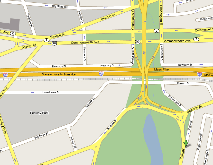
The greater Fenway area Directions from MIT
Toward Tower Records Directions from Hynes T stop/Corner of Newbury and Mass Ave. (walking)(Accessible from the Hynes Convention Center Green Line stop via the Mass. Ave. exit.)(See map, directly above.) If you are not on the side of the street with the bus shelter, cross the street. Now, face south, (think about direction, wonder why you haven't before) away from MIT/Newbury St., and toward Boylston St. The Prudential tower should be visible on your left. Walk south, crossing the Mass Pike; then cross Boylston St. Take a right on Boylston. After one block, you will come to a one-way street (Hemenway, though there is no street sign.) Cross it and continue walking on Boylston. After another block, you will come the corner with the Mass. Historical Society on it. Take a left. You are now on The Fenway, and should see lots of trees and grass on your right. Walk down to Number 34. All together it takes under 5 minutes. Directions From Kenmore Square (walking)(See map below.) Get on the south side of Commonwealth Avenue (the side with the McDonald's, CVS, the psychic, etc). Walk east/inbound (keep Comm. Ave. on your left). After a few blocks, at Charlesgate West, you will come to an overpass. Do not go under; instead, take the sidewalk up the on-ramp. Just after crossing the Mass Pike, you will see a crosswalk that leads to another crosswalk, that leads to a sidewalk near a large forest/swamp. Cross over until you are overlooking the Fens. Take a left and, keeping the Fens on your right, follow Boylston St. inbound until you see another intersection, with a road leading around the Fens (The Fenway). You should come to a point where you see a small turn-in with a parking lot, with a row of buildings on the other side of the parking lot. Fenway House is in that row of buildings, which includes the Boston Conservatory and the Berklee College of Music. Cross The Fenway, then seek number 34 and a big red door.
Toward Kenmore Square Directions From Symphony Hall (walking)(Useful if you missed Hynes/ICA, are stuck on the E Branch of the Green Line, or are walking in from the south.)The map below should guide you well. Simply put the Prudential to your right, and follow Mass. Ave. to Westland, and take a left. Follow Westland past Whole Foods (a supermarket and parking garage all in one!), through some Ionic columns. Bear Right onto The Fenway, directly to our front door.
Toward Symphony Hall Via Public TransportationThe Hynes Convention Center/ICA stop on the B, C, and D branches of the Green Line is the closest subway portal, though Kenmore Square, on the same line, is also close by. The CT1 and #1 busses also stop at Hynes; Kenmore Station connects to the 8, 8a, 57, 60, and 65 bus lines. If you are coming from another stop on the E branch of the Green line, you will find the using the Symphony stop much more convenient than transferring downtown. (See walking directions from all these stops above.) Via the MBTA, you can reach all subway, commuter rail, train, and ferry service in the greater Boston area, as well as Logan Airport. See the MBTA website for more information, including maps, schedules, and fares.
Click on the map above for a system map of buses and subway in Boston. Driving DirectionsThese are directions to the front of the house. To get to the back of the house, the best thing to do is pull up to the front of the house, run inside, grab a FenBeing, and take them with you around to the back. (It's rather complicated.) Also, if you are visiting us for any length of time, you should check with a FenBeing about parking in one of the two hotly contested, but very legal spots in our driveway. Otherwise, you'll most likely end up either paying $20 a day for an illegal parking space, or circling for hours in search of a legal spot or a cheap garage. From Massachusetts AvenueHeading southbound (away from Cambridge), you want to pass Virgin Records (on your left). After a long row of shops on your right, and a huge, strange-looking church on your left, you will arrive at an intersection just before Symphony Hall. Make a 120 degree (relative to your direction of travel) right turn onto Westland Ave. If you were heading northbound, you want to pass Symphony Hall, then make a 60 degree left turn (relative to your direction of travel) onto Westland. Then, just follow Westland past Whole Food Parking Lot and between the Ionic columns. You'll have to bear right as you come onto the Fenway, and you'll quickly see the blue mailbox in front of our house; pull into the driveway for the parking area. Do not turn onto Boylston from Mass. Ave., unless you are prepared to make a dangerously illegal left turn onto The Fenway. From Points North, East, and SouthFrom the Central Artery (Interstate 93 and/or US 1), follow signs to Storrow Drive. Follow Storrow Drive past Copley Square; you want to get off at the Fenway exit. Then follow the "from the ramp" directions below. From the Mass Pike/Interstate 90 (Points West)Get off at the Cambridge/Allston tolls, bearing to the right after the tolls. Follow the signs for Storrow Drive inbound (to Downtown Boston). You should end up taking a right before crossing the river. You will see signs for Kenmore Square and then Fenway. Get off at the Fenway exit, then follow the "from the ramp" directions below. (If you accidentally cross the river, take a right onto Memorial Drive, then take a right onto the Harvard Bridge, which is Rte. 2. Follow the directions from Mass. Ave. southbound, above.) From Route 20/Kenmore SquareRoute 20 East terminates in Kenmore Square. You then want to improvise a skillful driving maneuver which will result in you going just to the right of the bus terminal that lives in the middle of the octopus-like intersection, hopefully in the middle or right lane. This is Commonwealth Avenue inbound. Continue on until you see an overpass. Take a right and go up the on-ramp. Then follow the "from the ramp" directions below. From the RampAfter some rather stressful merging, you should see hurtling toward you you a road veering off to the left, labelled Boylston St. inbound, and a road veering off to right, labelled something else. You want to bear left, but stay in the right lane. At the next lights, take a right. Then take an immediate left at the blue mailbox into the turnaround/parking area. Fenway House is right behind the mailbox at Number 34. lick on the map above for a system map of buses and subway in Boston. Map of all of MIT's FSILG's (fraternities, sororities, and independent living groups).
|
||
Questions? Email zatheodo@mit.edu.
34 The Fenway, Boston MA 02215. 617-437-1043.
![]()